
A spatial approach to evaluating the multiple benefits of Sustainable Drainage Systems using blue-green infrastructure
Description
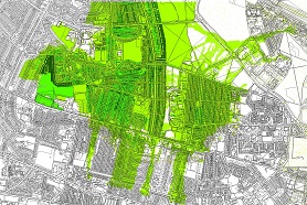
Traditional approaches to understanding the benefits of SuDs adopt cost-benefit analysis and ecosystem services methods often rely on value transfer to convert each benefit into a monetary value which can then be compared to the cost of the project. This approach while well-developed is limited because it does not incorporate the spatial nature of the benefits, and fails to emphasise that different beneficiaries are benefiting in different ways. This paper develops an alternative way of evaluating and comparing benefits, which allows spatial distribution and local context and circumstances to be taken into consideration. The suggested approach is to create a score for each benefit category which is normalised against a defined initial condition state on a scale of 0-10. This approach allows a direct comparison of the relative magnitude of benefits for a given location and provides a clear understanding of how (and to whom) multiple benefits accrue. The approach allows a singular significant benefit to be compared against many minor benefits, and the method can easily be modified to reflect local stakeholder preferences by weighting each benefit category appropriately. The method is demonstrated by the application to a case study, based in Newcastle in northern England.
External URI
Links
Subjects
- Sustainable engineering -- England -- Newcastle -- Evaluation
- Drainage -- Evaluation -- Methodology
- Flood risk management, multiple benefits, Blue-Green infrastructure, GIS evaluation, tradeoffs
- Engineering::Civil engineering::Environmental engineering
- G Geography. Anthropology. Recreation::GE Environmental Sciences
Divisions
- University of Nottingham, UK Campus::Faculty of Social Sciences::School of Geography
Deposit date
2017-05-31Data type
GIS images files, excel spreadsheets with multiple benefit evaluation dataContributors
- Morgan, Malcolm
Funders
- Engineering & Physical Sciences Research Council
Grant number
- EP/K013661/1
Parent project
- Blue-Green Cities Research Project
Collection dates
- April 2015 - January 2016
Coverage
- Newcastle Upon Tyne, UK
Data collection method
Analysis of GIS data created using the Blue-Green Cities Multiple Benefits GIS Toolbox (run in ArcGIS 10.3).Resource languages
- en
Copyright
- University of Cambridge